There is Dolpa, Lower Dolpa
and Upper Dolpa..but then there is the real Dolpa
Much has been written about Dolpa and many
have trekked through the wild mountains and valleys but few have explored the
real heart of Dolpa and for no other reason other than it is wild and above all
very remote. Initial access is either by plane from Nepalgung or by road followed by a
long hard 14 hour walk to reach Dunai but soon this road will go all the way to
Dunai. However, no matter the means of entry to Nepal’s largest National Park
to really explore the wilderness beyond you need to allow at least 14 – 20 days
just for the walk in to the northern part of the district, then another week or
two for the walk out most of which is above 4500m.
 |
Dolpa provides a real wilderness experience for those who are seeking
adventure in Nepal, the trails are vague, villages far and few between
and trekkers certainly require good mountain skills ©Ian Wall
|
Nepal offers more than 100 unclimbed peaks
open for mountaineering expeditions but few offer the remoteness of the unclimbed
peaks as found in Dolpa. By many standards these mountains are not high but
they do offer some challenging lines and all are away from immediate assistance
or rescue, they are remote!
 |
Danphe Sail as seen from the broad valley a little
below the south face,
the sharp peak in the background is not Danphe Sail but as
the most
striking summit it is often confused for the same. The border with
China
runs up the glacier on the left (west) across the dome of Danphe Sail,
the
lower of the two peaks and then continues along the eastern ridge.
The obvious
line is up the loose and broken rock of the south face to
the isolated boulder
in the ice above, from that point head up towards
the summit. Alternatives are
capped by nasty terrain! ©Ian Wall
|
Danphe Sail 6103m is one once such mountain that
has attracted limited attention. Set straddling the border between China and
Nepal Danphe Sail has a far more prominent neighbor that I would suggest had
initially attracted the attention of would be summateers but this neighbor is
well and truly in China and off limits.
 |
June still witnessed thew remnants of the spring snows with several
passes providing difficult conditions for the ponies ©Ian Wall
|
As far as I can establish up to 2016 there
had been only two attempts to climb Danphe Sail. The prolific
mountain explorer Tamotsu Ohnishi and four companions visited the region in
2009 when they planned to climb Danphe Sail but then abandoned their attempt. A
second attempt was planned but again Tamotsu Ohnishi, with a Japanese companion and
a Sherpa, headed for Danphe Sail. In May and June 2010 the three established
base camp below the south side of the mountain at 3,900m and Camp 1 at 4,200m.
Ohnishi became ill from insect bites on his feet that had become infected and
they abandoned the climb. Ohnishi’s were the first recorded “attempts” on the
mountain.
Lindsat Griffin, Mountain INFO,
Elizabeth Hawley, AAC Honorary Member,
Nepal and Richard Salisbury The Himalayan Database 2012
I also understand that an Australian team approached Danphe Sail but
decided it was too technical so abandoned their attempt. It was likely that
they mistook the distant peak for Danphe Sail as both seen from a certain angle
could be mistaken for one of the same.
 |
Our 2016 Danphe Sail team, Michael Salmon, Alex Cramb, Bill Crozier
and
Alastair Lawrence and some of the locals from Ku © Ian Wall
|
In June 2016 I organised a small Anglo Australian expedition
comprising of Alex Cramb, Alastair Lawrence, Bill Crozier and Michael Salmon
along with two Nepali climbers, Chhering Bhote and Wonchu Sherpa with the
objective of making the first ascent of Danphe Sail.
The trail from Duani to Bhijer is well documented as it links the route
to the north via Shey Gompa. Bhijer is
the local administrative district head-quarters and although it is situated on
the route of the Great Himalayan Trail it boasts little in the way of
amenities.
 |
Seen from the watershed between Yambur Danda and
Kyala Lek. Kugoan
is situated in the obvious large east - west valley in the middle distance of
this image, our objective Danphe Sail can be seen as snow dome below
the highest mountain on the skyline mid image, another 6 days further on!
©Ian Wall
|
Leaving Bhijer our team headed east following the Yamchho Khola to
Phulak before turning north and ascending a long and undulating 1000m climb to
cross the main east-west watershed between the Yambur Danda and Kyala Lek. The
landscape was as expected, barren with virtually no respite from the grueling
climb, the sun was beating down and with no shade and no water all we could do was to bite
the bullet and get on with it. However the distant views provided plenty of
excuses for stopping and taking photographs. The early start turned into lunch
time and then evening began to draw in. Once on the watershed the indistinct
trail dropped down to a small kharka, another opportunity to sit and view our
surroundings when out of nowhere a young Nepalese man appeared. Pema joined us and
we all got involved in a short conversation. It turned out that this young man
was from Ku, he had set out a few hours previously with the intention of going
to Bhijer to collect medicines for a friend, a journey he said would only take
him four to five hours! I could have sat on that ridge watching the sun set for
the next couple of hours but that would not have gotten me anywhere nearer to
our destination in Kugoan.
 |
The long descent into Kugoan situated in the bend of the river ©Ian Wall
|
The team pressed on however despite there being little water we were forced
by a combination of tiredness and darkness to camp at the small kharka near the
Yaje Danda at 4742m. The kitchen staff, as committed as ever to the welfare of
the team, then set out on a two hour round trip to find water and fill a blue
expedition barrel which they then carried back to camp – an amazing effort
after such as hard day (for us!!).Traversing the hillside the following morning the
expedition eventually reached the end of the ridge at 4740m from where we were
presented with the magnificent views to the northern border mountains but more
essentially the impressive descent of 1100m to the village of Kugoan. The path
was not difficult but as if to beckon us on, the view and details of this remote
community got clearer and nearer with every step.
 |
Once down at the level of Kugoan the community appears to be well
organised, the houses are well maintained and many have walled off
courtyards.
The buildings are very obviously built in Tibetan style
with the walls tapered
as they rise. Inside the lower level is occupied
by the animals while people
live above. The soil after generations of
cultivation is richly improved with
the use of animal fertilizer.
©Ian Wall
|
Entering Kugoan was a step back into the middle ages yet there was a
certain uniformity in the way things were organized with the terraces being
newly ploughed and looking particularly fertile although the rich brown soil
faded into the neutral colours of the surrounding barren hillsides. The houses
were of a typical Tibetan style and the community was punctuated with lines of
chortens. The locals made us very welcome giving us a tour of their school
buildings and the monastery, accompanied by invitations into their homes for
a glass of ‘local wine’. After a day’s rest, reorganization and the storing of excess
gear in a local house time was spent answering many questions and explaining
how an ice axe might be used or what the shovel was used for from the inquisitive locals
who were adamant that we were the first foreigners to pass through their
village.
 |
The local people were very interested in all
our equipment especially
the technical climbing gear, ice axes, rock gear and
the ropes ©Ian Wall
|
A fact I found hard to believe, however, judging by their
inquisitiveness it might well have been true. The village nestles in a shallow
bend in the river but to both the east and the west the terrain certainly did
not encourage travel in either direction there were two ways out on the valley,
going north to the border or south to habitation. On this expedition we had arrived
from the south but would exit to the north.
 |
The gorge was dark, intimidating and early in
the morning cold and
dank. In places the sun’s rays clipped the more open
cliff, the way
ahead was inviting and the higher we got the more light we could
see at the end of the tunnel. ©Ian
Wall
|
The village holds the key to further progress, initially crossing the
Tora Khola by a small bridge and then entering the very narrow gorge of the
Jhyanblung Khola with its monolithic sided cliffs. The narrow canyon only a few
metres wide in places stretched for approximately 7kms with the indistinct
trail crossing and re-crossing the Khola many times before opening out at the
confluence with the Shang Khola. One could only guess at the stability of the
gorge walls, however not dwelling on the possibilities for too long we pressed
on at our own individual paces.
 |
Along the valley approaching the valley to our intended
Base Camp, heading up towards the clouds!©Ian Wall
|
At this point our route took a sharp eastward bend and climbed onto a
higher shoulder above the river. A bit of time was taken checking out the route
from the shoulder and as in many mountain situations the right way looked the
less probably way and a further steep ascent onto a short ridge lead to a slow contouring descent. Within a further two kilometers we reached a
wonderful kharka and decided to call it a day, but to the north we could see
our objective however, now with some ominous dark clouds rolling down the
hillsides.
 |
Once in the valley leading to Base Camp careful navigation was
required to find the best route for the mules Danphe Sail already
in the clouds ©Ian Wall
|
The following morning dawned clear and bright but the route up the broad valley leading to our base camp took some careful navigating to find a safe route through the boulder fields for the mules. Reaching the flat basin under the south face of Danphe Sail we quickly organized base camp. The mules were unloaded and then retreated to the previous kharka for the duration of our stay in Base Camp. We were in high spirits.
 |
The joys of Base Camp, even
if a bit chilly! The direct approach
via the shallow snow filled gully can be
clearly seen in the middle
of the image leading up to the col. ©Ian Wall
|
Base Camp was ideally situated in a shallow basin just short of the
lake, there was a small but fresh and constantly flowing stream was close at hand and
plenty of flat ground covered in a light ground hugging shrub to make life
comfortable. During the afternoon of the day of our arrival we decided to do a
quick recce of the site for ABC. From Base Camp there were two ways to reach
the col, either to approach up a shallow gully hidden behind some lateral
moraine or to approach the col directly up a shallow snow filled gully. We looked at both but the direct option was the preferred route
taking only an hour to gain the col. The initial plan was to make the col the
jumping off point for the summit attempt.
 |
From what we though might provide Base Camp the col was
obviously too rocky but the way ahead to the large
exposed rock in the snow looked straightforward even if a little
foreshortened . ©Ian Wall
|
The first day in BC saw Chhering, Wonchu and myself head off to what
was possibly going to be the site of ABC but on arrival the small col was much
too rocky so while I descended back to BC Chhering and Wonchu headed up the
rock pitches to complete the recce to the foot of the snow field. Meantime the
‘boys’ enjoyed the ambiance and surroundings of BC.
 |
The snow fell, it melted at
Base Camp but then there was
another fall, which almost melted at Base Camp
before there
was another fall, the mountain did not look good! ©Ian Wall
|
Day two at base camp saw the weather change, occasional snow showers
accompanied by a brisk cold breeze.. it did not look good. However we amused
ourselves doing a bit of rope work and generally brushing up on our snow
skills.
 |
| The weather did not look good ©Ian Wall |
Day three saw Chhering and Wonchu set off in the dark to try to get a
purchase on the snow field at the top of the rocky section but they returned
within a few hours saying that the snow was in fact hard blue ice that
shattered at the blow of each axe placement and with the wind and snow showers
frequent slurries of spindrift were making things difficult. They were back by
lunch time and we all headed into the cook tent for more tea and biscuits.
 |
| Then it got progressively worse ©Ian Wall |
Sadly, the next few days saw the same weather pattern develop with
deteriorating conditions. We discussed our options – to stay and see if things
changed or to head down immediately. We spent time ‘playing’, packing and re
packing gear, sorting the tents out, eating, drinking, reading and generally
participating in all the mundane activities normally pursued while awaiting the
weather in the mountains.
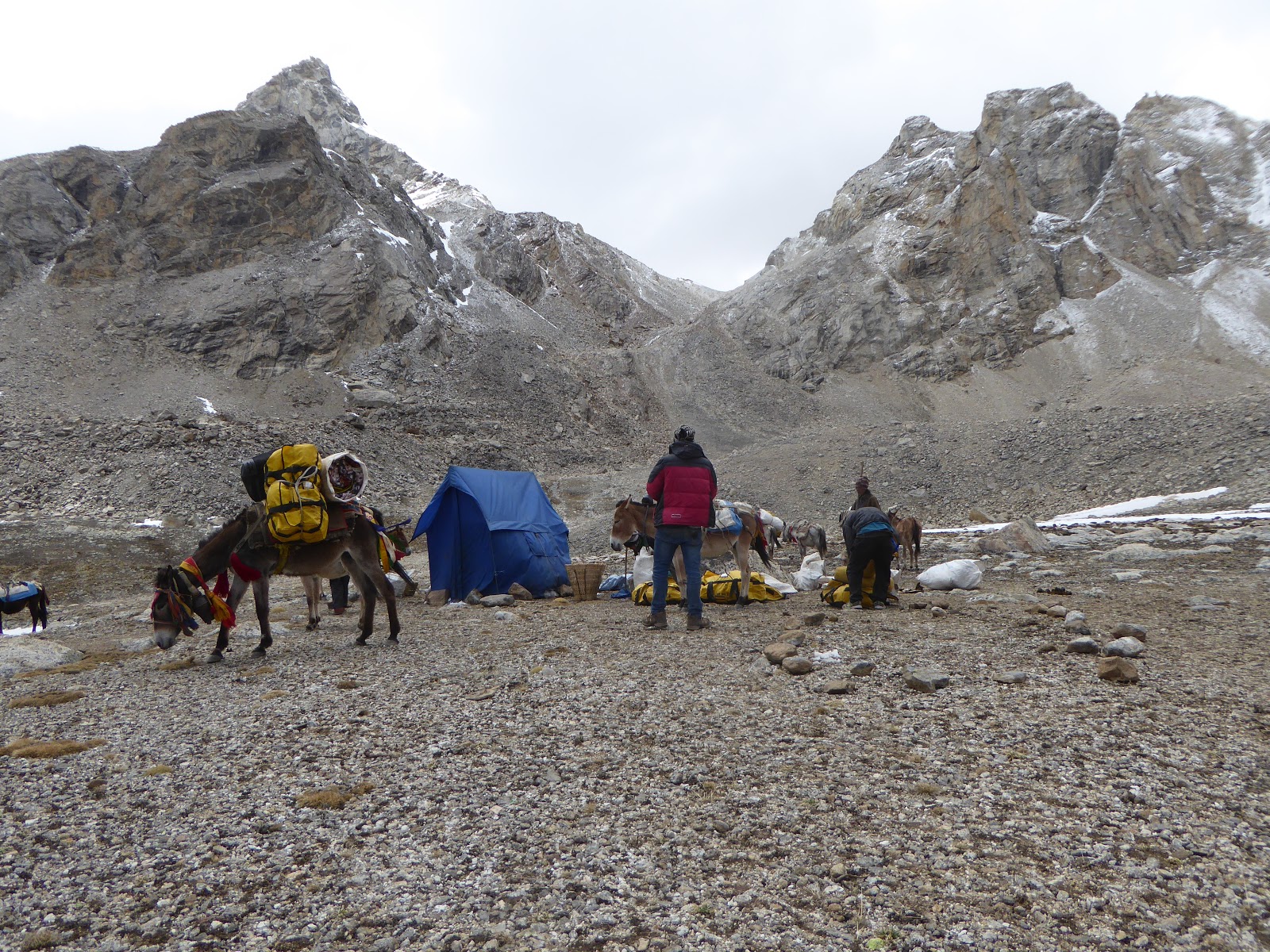 |
| Finally a decisions had to be made, the mules were called in and we packed up ©Ian Wall |
The team decided to give it as long as they could but after five days
we had exceeded our time and were faced with not having sufficient days left to
walk out. One of the kitchen boys ran off down the valley to call for the mules
to come up. They duly arrived and we struck camp and began to withdraw back
down the valley. We covered the two day ascending trek in to BC in a little over half a
day but decided to stop at the big kharka that the mules and their handlers had
occupied for the previous several days. From here it was going to be a long haul all
the way back down the gorge to Kugoan.
It had been two weeks since we left Ku but within that time the fields
had turned green and the growing season was well underway.
 |
| Our last camp site back in Kugoan and what seemed like a completely different world ©Ian Wall |
We spent
our final night in camp on the bank of the Tora Khola with our new friends from Ku. In the morning as planned we heard the helicopter and in fact saw it for
a fleeting moment, but then it disappeared. As if to highlight the remoteness
of the village the pilot failed to find the village, despite the fact he must have been
within a kilometer of the community and with GPS. He returned to Bhijer to pick
up a local to act as an aerial guide, he returned and with two shuttles the
team were back in Dunai. However despite constant pressure from us and the
offer of, additional funds the pilot refused to give the local ‘aerial’ guide a
lift back to Bhijer.. he had to walk!
 |
| Thanks Dolpa for another great trip and see you in 2018 .. when we'll be back ©Ian Wall Other memories         |
